Add data
Import your own data
Connect a source URL or bring a file from your device onto the map.
Connect a URL
Use a direct data or service URL, rather than a link to a web page containing a map. OpenGeo recognizes GeoJSON, ArcGIS features and imagery, WMS, WMTS, and XYZ tile templates.
- Open Layers → Add layer from URL and choose URL / service.
- Paste the address under Where is the data? and select Detect. If the suggested format is wrong, choose another format below it.
- Select Next. A direct ArcGIS feature-layer URL opens Create query; for a service with several layers, choose a layer first. Other formats may ask for a title and source settings.
- For feature data, continue to Create query, check the layer name, and review the preview. Choose Add without filters or set filters before adding. For imagery or tiles, select Add layer.
- WMS needs the layer names listed in the service’s GetCapabilities response.
- WMTS needs a layer, style, and tile matrix set from the provider.
- XYZ uses a tile URL template with {z}, {x}, and {y} placeholders.
- To paste GeoJSON instead, choose the Paste tab and provide a Feature or FeatureCollection.
Detect a direct layer URL, review Create query, and add the source without filters. The data.example.org address is illustrative and uses synthetic station data; use your own service URL.
Read the text walkthrough
- Open Add your own data, then choose URL / service.
- Paste a direct ArcGIS layer URL and select Detect. This example uses a fixture-backed address, not a public endpoint.
- Select Next to open Create query. Check the layer name and the matching-record preview.
- Select Add without filters. Sample stations appears in Layers.
Import a file
Supported formats are GeoJSON, CSV/TSV, KML/KMZ, GPX, and zipped Shapefiles. Files are processed and saved on your device. The current limits are 64 MB and 100,000 records per file.
- Drop files onto the map, or open Layers → Add layer from URL, choose Files, and select Choose files.
- Select Inspect files. Review the detected format and any settings. For CSV or TSV, confirm the longitude/X column, latitude/Y column, delimiter, and coordinate system.
- Select Prepare layers. Review the feature counts and import notes. Use Preview extent to check the location and Preview attributes to check the values.
- Choose the datasets to include and name each layer. You can also choose Configure query and time, set a group name, or turn on Zoom to imported data.
- Select Add layers. If records are invalid, either fix the file or explicitly choose to skip those records before adding the valid ones.
Watch two sample stations go from a CSV file to a map layer. Silent walkthrough using the real app.
Read the text walkthrough
- Open Add your own data from the welcome dialog. In an existing workspace, use Add in the Layers panel.
- Choose stations.csv and select Inspect files. Confirm longitude as X, latitude as Y, and EPSG:4326 as the coordinate system.
- Select Prepare layers, open Preview attributes, and check the Harbor and Park rows.
- Select Add 1 layer. The stations layer appears and the map zooms to its data.
Try a small CSV
Save this as stations.csv. During inspection, use longitude for X, latitude for Y, and EPSG:4326 for the coordinate system. X is longitude; Y is latitude.
name,longitude,latitude,temperature
Harbor,-74.0060,40.7128,18
Park,-73.9654,40.7829,21
After import, you should see two points in New York City, each with a name and temperature.
If something looks wrong
Start with the import notes or source error. For files, select Report to download the diagnostics.
- Points in the wrong place: check X/Y order and the coordinate system. Projected coordinates need their actual source CRS, not EPSG:4326.
- Missing records: check the invalid-record count and any filters you configured. Skipping invalid records leaves them out of the imported layer.
- A URL will not load: check that it points to the data, that the service is available, and that it allows access from your browser. A sign-in page is not a data endpoint.
- A large file fails: split it into smaller files within the limits. If browser storage is full, back up your work before clearing unused data.
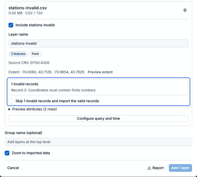
This example has two valid points and one row with a missing coordinate. Add stays disabled until you fix the file or explicitly choose to skip the invalid record. Use Report to download the diagnostics.